Thursday, August 11, 2016

The Lacs Noir amongst the Aiguilles Rouge

The téléphérique from Plan Praz near Chamonix lifts you quickly up to nearly 1900m asl to La Flegère. Working on my fitness I walked from here up the piste to reach top of the Index chairlift. From here I was to descend for around 100m vertical before beginning the climb up a high, snow banked valley to reach the Col de la Glière. There had been warnings posted at the caisse where I bought my tickets - the advice for walkers was not to cross the Col because of snow but I wanted to check this out as I'm planning to walk this route next week with my group. I thought I'd walk up to the col and check out the problem but as it turned out the problem was before reaching the col.
Crossing the dodgy snow gully
Ahead of me I could see people picking their way carefully across a small snow gully. Without a rope for protection, crampons and an ice axe this can be a bit delicate. A slip will be hard to control and a fast slide will end up in rocks below. On the far side of this gully there were stanchioned hand rails where the path continued across steep rocks to the col. When I got up there I decided I didn't fancy the slippery snow and instead climbed above the snow to regain the path.
An icy Lac Noir in front of the Aiguille du Pouce
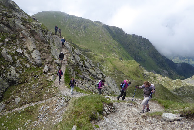
 After the excitement it was quickly to the col and then another 100m of up to get to the Lacs Noir which were ice filled and atmospheric below the rocky pinnacles of the mountains. The path slides onto the north side of the main ridge here to get to the next col from where a steep path zig-zags downwards. The views are magnificent and the path interesting once I'd lost a couple of hundred metres altitude. I chose the path advertised as 'steep' which followed a small subsidiary spur downwards through bilberries and little rocky knolls which framed a wonderful view of Mont Blanc and the Bossons Glacier cascading downwards towards Chamonix. 200 years ago this nearly reached the floor of the valley but it's melting back fast.
Mont Blanc and the receding Bossons Glacier
The Aiguille Vert and the Dru above some 'weeds'

This descent takes you back into areas of skiing detritus but not long after turning back towards La Flegère there's a turn, briefly uphill and then traversing a beautiful path.
Walkers silhouetted against Mont Blanc and Mont Maudit
 This path amongst mature conifers offers more of the fantastic panorama, southwards towards the high mountains. This is a pretty stunning walk.
 The distant Aiguille Vert nestled in cloud across the valley from the La Flegère path

Tuesday, August 9, 2016

Argentière


Argentière sits a few miles above Chamonix in the deep cleft of the vallée de l'Arve, below the highest mountains of the western Alps. I've come here to recce, then lead a week long walking holiday - day walks from a base in the village. I prefer Argentière to Chamonix; it's less busy, smaller, and was where I first came to begin my alpine mountaineering about 30 years ago.
I arrived on Sunday, greeted by 'beau temps', camped a night then headed yesterday up to Lac Blanc via the Aiguillette d'Argentière, a pinnacle of climbers' granite poised high above the village.
Back to Le Tour and the Aiguillette d'Argentiere
It's a steep walk, firstly shaded by conifers on a path which zig-zags up an 800m vertical height gain, to reach the traversing footpath below the Aiguilles Rouge. This followed by a further 400m upwards to the lake itself. I meet a couple of Israeli guys walking the Tour du Mont Blanc and we walked together - English our shared language. It was hot, even beneath the trees' welcoming shade, and by the time we climbed out above the tree line into the full power of the sun I was leaking sweat faster than I could drink. Around 1800m asl the path gets exciting as it traverses into the arena of the Aiguillette d'Argentière, from which the only escape for non-climbers is a series of ladders, ropes and stanchions. Up here the path winds a vertiginous route.
Ladders
Chamois and kid
Hereabouts the mountain chamois are accustomed to people and I passed several, nonchalant, perched near the path. Eventually, around 2100m the steep path joins the main popular route that reaches the Lac Blanc.
This section was very busy with walkers, queuing in places to use the wooden rungs fixed to aid the way over the steeper rocky slabs that bar the way to the lake. I don't much like these rungs, which can occasionally be wobbly, and the presence of queues of people above standing in loose scree makes me nervous. In the dry it seems preferable to trust to friction and wander up the clean rock just to the side.
The glacial troughs of the Argentiere Basin and the Mer de Glace enclose the Aiguille Vert
I didn't linger at Lac Blanc, beautiful though it is. In August the tourist hordes (I know I'm one of them) create a noisy massed picnic, harassed by flocks of Alpine Choughs for easy pickings. I preferred to return a little for my picnic, dropping down to find a much smaller pathway leading off the beaten track down to the Lacs de Cheserys.
Lacs de Cheserys
Alpine Newt
These lower lakes don't have the alpine majesty of Lac Blanc but are quieter. I dangled my feet in the cold water and watched an Alpine Newt swim past on a mission.
Perhaps the most obvious wonder of this walk is the view. The Aiguilles Rouge on which this walk lies face northwards to the grand peaks, the Aiguille du Chardonnet, Aiguille Vert, all the cluster of Chamonix Aiguilles and finally the remote white dome of Mont Blanc rise across the valley on a scale which is difficult to comprehend even as you gaze across.
Mont Blanc across the void
Aiguille Vert
The ranges are split by the wide gulfs of the Argentiere Glacier and the Mer de Glace, though these glaciers are visibly reduced since I was first here thanks to climate change. It's an inspired and mighty sight.
Climber between pinnacles on Aiguillette d'Argentiere
After a picnic by the Cheserys I plunged back down the ladders and into the woods, an hour and a half of rapid descent back to Argentière.
  
Back in the shade, but still high above Argentière

Saturday, July 16, 2016

Another walk by Lake Como

I'm jumping back in time to my June visit to Como with this post.
Around Lake Como it's easy to get around with public transport. Trains, buses and ferries provide a network which I've relied on to get my groups to and from their walks. Gravedona has been my base for these holidays and the C10 bus, which runs along the western shore of the lake, between Colico and Como, via a terminus at Menaggio, is indispensable.
(I've come to really appreciate and even enjoy bus services in Italy. They're driven by professional drivers who seem proud of their status in contrast to the sense I've sometimes had of their English counterparts. I've encountered flamboyant and colourful Italian bus drivers as well as some grumpy ones but they have a pride and assuredness in their driving and their buses - one feels driven by someone with ownership whereas in the UK you're driven by a corporate company.)
In mid June my group and I took the C10 from Gravedona to Menaggio, switched to the C12 towards Lugano and got off after just a few minutes in Croce. Croce lies 200m higher than Lake Como so we'd saved ourselves 200m of uphill before starting our walk, to Tremezzo via Monti di Nava.

Uphill, grateful for the shade
The walk begins immediately uphill and we chose the zig-zag road in places over the overgrown and fiercely steep footpath. The road is easily graded by comparison and carries only the occasional car heading for the golf course. Our route leaves the tarmac after 150m vertical height gain and takes a track which continues to wind cleverly uphill through the steep woodland. Most of the ascent is in the north facing woods, which is a boon on hot sunny days. There are occasional clearances where it is possible to pause and look down on Croce a few hundred metres below.
Eventually the slopes seem to relent a little, coinciding with a change to beech trees, their grey trunks as columns to a dense canopy, leaf litter covering the open ground beneath and between them. This is now quickly followed by the reaching of a level saddle and a small open meadow cleared from the forest. The first climb is done and you're at around 800m asl (above sea level).

Eyes on the path, not the view

Crossing over the saddle leads to a short descent and another meadow sloping dramatically down the the south and the first sight of a view which is to open up and grow wider for the next half hour. You pass a couple of small inaccessible holiday chalets and climb again, dramatically between cliffs. This is no place for anyone not sure-footed. The path is easy but narrow and a fall from the path would not have a happy ending. With a reminder not to walk and look at the view at the same time we made our way via a series of zig-zags to reach a pylon and the high point of the walk.
The view from here is immense. You can look southwards into the two southern legs of Lake Como over the town of Bellagio and you can look northwards up towards the Sondrio valley. The lake, far below is surrounded by mountains, their steep slopes rising directly from the shore.

From Monti di Nava high above Lake Como and Bellagio

A tight bend for a vehicle but don't worry - that guard rail makes you feel secure!?
The descent goes via a few chalets at Nava and down a narrow 'road', occasionally concreted and a hairpin bend which you cannot imagine driving, except that there are a number of iron posts concreted in at the edge - why put them here if not to provide a barrier for vehicles against the drop!?
The Ridge below widens and limestone juts through the earth - flowers are everywhere.
Jan, Penny and Clive descending
 The path descends on the left side of the broad ridge in a series of steep zig-zags to reach the farmland below, from which a short walk on tarmac brings you to the lakeside. In the heat the water of Lake Como is extremely inviting for feet, swollen and bruised on the descent.
Clive, like King Canute

Friday, July 15, 2016

Monte Elmo Ridge Walk


Crazy crenelations across the valley
On the north-eastern fringes of the range, on just the European side of the Peri-Adriatic Fault, which divides the European Plate from the African Plate, the geology determines a different kind of mountain from the crazy, crenelated pinnacles of Dolomitic Limestone on the other side of the valley.

Here grassy slopes, broken with outcroppings of schist, rise smoothly to an undulating grassy/rocky crest running NW to SE, and marking the border between Austria and Italy. This is skiing country, above Sexten, and the gondola at Vierschach takes you effortlessly up to 2000m asl (above sea level). From the gondola station you can walk the ridge over Monte Elmo, past the Sillianer Hutte and continue to the Rotecksattel.

You begin with a climb and if you've been at sea level the shortness of oxygen makes you gasp a bit – the summit of Monte Elmo, with its disused hut is at 2434m. I suggest avoiding its steep and eroded SW ridge. I much prefer the NW ridge which is less used and breaks through some exposed and interesting rock bands around 2300m.

Up through the bands of schist - it looks a bit Scottish!
The ridge continues, an airy walk and on a clear day gives a succession of 360° views over grassy meadows full of alpine flowers to distant mountains; leftwards to the Austrian Tyrol and rightwards to the majestic Dolomites.
Along the ridge
Descending from the ridge through Alpenrose

Who's looking at whom?
The Sillianer Hutte is best avoided on busy days – earlier this year my group gave up waiting for their order after 45 minutes. Better to picnic amongst the marmots which swarm the slopes, their warning whistles heard long before they can easily be seen.


From the Rotecksattel we left the ridge and dropped into the valley to about the 2000m contour line before turning back towards the north-west and the Klammbachalm hutte, after which a short but leg burning burst takes you up to the Tre Cime Gondola. We were late after our failed hut stop and rushed, headlong - a bit like the previous sentence.
A pause between mountains

If you’ve had the foresight to buy a return ticket from Vierschach this gets you swiftly down to the roadside and a bus ride back to San Candido.